This post describes in detail how to add GPS data to video file using `visual correlation' (see also: Video geocoding with gpsbabel).
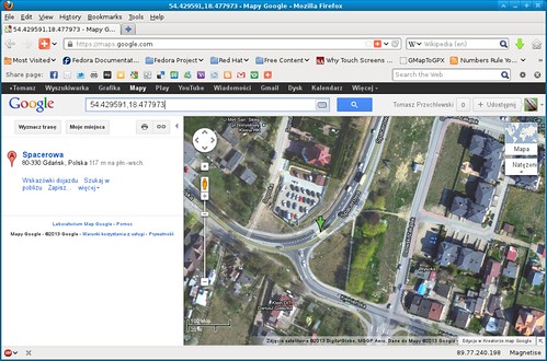
Crossing at Osowa
There is an easy way to augment video files with GPS data using GPSbabel. Since version 1.4 of GPSBabel is able to create a subtitle file from a GPS tracklog. The subtitle contains latitude/longitude/altitude as well as the time. With a simple Perl scripts I have added current speed (not particularly accurate however).
To convert GPX file to subtitles one have to execute:
gpsbabel -i gpx -f FILE.gpx -o subrip,video_time=hhmmss,gps_time=hhmmss,gps_date=YYYYMMDD -F FILE.srt
Where: video_time -- video position (relative to beginning of video) for which exact corresponding GPS timestamp is known. gps_time -- the time part of the GPS timestamp which corresponds to a known position in the video. gps_date -- the date part of the GPS timestamp which corresponds to a known position in the video.
On a video (see below) you can see that in 34 second I passed the zebra crossing. The zebra's crossing coordinates can be easily identified at Google Maps (cf. picture Crossing at Osowa). Now one have to search the GPX track for the point which is nearest to 54.429591/18.477973. I developed a simple Perl script for that purpose:
$ perl My_GPX_nearest_timestamp.pl -c 54.429591:18.477973 20130420.gpx
*** USAGE: My_GPX_nearest_timestamp.pl -c latitude:longitude GPX-file
*** Looking for 20 points near: 54.429591:18.477973 (lat/lon) ***
> 15.3758195746663 2013-04-20T10:27:09Z  54.429509640:18.477780819
> 22.0617273294607 2013-04-20T09:05:15Z  54.429701502:18.478256240
> 32.6458959467509 2013-04-20T10:27:15Z  54.429787332:18.478348190
> 43.3771684316959 2013-04-20T09:05:24Z  54.429531014:18.477310427
> 47.7727043140018 2013-04-20T09:05:11Z  54.429905936:18.478475260
> 63.903936892351 2013-04-20T10:27:00Z  54.429627573:18.476987137
> 70.171200323179 2013-04-20T09:05:28Z  54.429655485:18.476893930
One can stipulate from the above output that I passed a point 15,4 meters away from 54.429591/18.477973 at 10:27:09 GMT as well as I passed another point which is 22 meters away from 54.429591/18.477973 at 09:05:15. As I cycled back and forth along the same route the second point is valid, the first is accidentally closer but as the time is almost one and half hours later it is clear that I was there on returning home. So gpsbabel should be executed as follows (20130420.gpx contains GPX track):
gpsbabel -i gpx -f 20130420.gpx -o subrip,video_time=000034,gps_time=090515,gps_date=20130420 -F 20130420_1.srt
Speed is added with another very simple Perl script:
perl add_speed_2_srt.pl 20130420_1.srt > 20130420_1_S.srt
Just to remind: internally all GPS units record time/date using Coordinated Universal Time aka Greenwich Mean Time vel Zulu time (for army enthusiasts). What the unit displays is another matter (usually it displays local time).
Ten wpis jest bardzo pomocny. Bardzo podoba mi się jego treść.
OdpowiedzUsuń